Guestuser: Login or enrol?
- Home
- Main Display
- Main Display (Old)
- Find a Walk
- Display INTRODUCTION
- DONATE
- Click below for your
profile & contributions
guestuser- News
- Tracks, Walks
- Challenge
- Community
- Lists & Logs
- Popular Lists:
- County Highpoints
- Range & Area Highpoints
- Local 100
- Highest Hundred
- Vandeleur-Lynams
- Arderins
- Carns
- Best rated
- Irish 900 up
- Irish Island
- Munros
- All Lists
- Shorter Irish
- County Highpoints
- Range & Area Highpoints
- Highest Hundred
- Local 100
- Local 100 (pre2014)
- Local Historical Cultural
- Best rated
- Irish 900 up
- Larger Irish
- Arderins
- Arderin Begs
- Arderins + Arderin Begs
- Vandeleur-Lynams
- Vandeleur-Lynams + Arderins
- Carns
- Binnions
- Highest 50 per Province
- Island Features
- Irish Island
- Coastal Hills
- Irish 600 up
- Irish 500 up
- British
- Munros
- British 600 up
- British 500-600
- British Marilyns
- Comprehensive
- All Irish summits
- All Irish features
- All British summits
- All Britain+ Ireland
- Special
- Analysis List
- Simple Irish Listings
- Simple Irish & British Listings
-
- More
- Motley Views
Welcome to MountainViews
If you want to use the website often please enrol (quick and free) at top right.OverviewFor more map options click on any overview map area or any detail map feature.Detail Map FeaturesShowing 8 items:
Binn Chaonaigh 633.5m, Binn Mhairg 612.4m, Bunnacunneen SE Top 479m, Knocknagur 310m,Tracks:3103, 29km 3238, 17km 5221, 9km 3557, 8km Find Suggested Walks
Find hill, mountain, island, coastal feature.Videos


Users Online:
Guests online: 26Recent Contributions
 Get Notifications
Silvermine Mountains East Top: East Top is Easy Top
Coppanagh: I'd go now if I were you.
Silvermine Mountains West Top: Fab hill
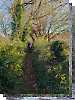
Dargle Gorge near Enniskerry, North Side.
Hell or high water
Bree Hill: Bree no longer a breeze
Rostrevor: Kilbroney Forest Park with description
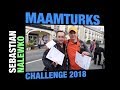
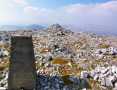
Binn Chaonaigh: Havoc on the Maamturks!
Mount Kid: A small grassy hill top with amazing views towards the sea and beyond
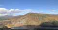
Corraun Hill: Corraun at the double
Errisbeg Loop from Dog's Bay Beach
Knocknacloghoge: Viewed across Lough Dan
Conditions and Info
Use of MountainViews is governed by conditions and a privacy policy.
Read general information about the site.
Opinions in material here are not necessarily endorsed by MountainViews.
Hillwalking is a risk sport. Information in comments, walks, shared GPS tracks or about starting places may not be accurate for example as regards safety or access permission. You are responsible for your safety and your permission to walk.
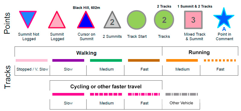
See the credits and list definitions.Video displayMaamturks Area S: Maumturks S Cen SubareaPlace count in area: 27, OSI/LPS Maps: 37, 38, 44, 45, EW-CON
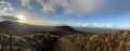
Highest place: Binn idir an dá Log, 702m
Maximum height for area: 702 metres, Maximum prominence for area: 629 metres,
Places in area Maamturks:
N: Leenaun:Maumturkmore 488mBúcán 550mLeacan 556.8mLeenaun Hill 616mLettershanbally 323mMeall Cheo 578mTaobh Dubh 422m
N: Maumturks N Cen:Barrlugrevagh 558mLetterbreckaun 667mLetterbreckaun NE Top 603mKnocknahillion 607mKnocknahillion North Top 541mCúlóg 435m
S: Maumturks S Cen:Binn Chaonaigh 633.5mBinn idir an dá Log 702mBinn idir an dá Log SE Top 659.3mBinn Mhairg 612.4mKnocknagur 310m
S: Maumturks South:Binn Mhór 660.6mBinn Mhór NE Top 641.2mBinn Mhor West Top 595.8mBinn Mhor East Top 631.3mLissoughter 401mCorcogemore 610.1mMullach Glas NE Top 432mLackavrea 396mMullach Glas 621.3m
Note: this list of places includes island features such as summits, but not islands as such.
Galway County in Connacht Province, in Binnion List, Marbles, metavolcanics, schists, grits Bedrock
Height: 310m OS 1:50k Mapsheet: 38 Grid Reference: L92600 53270
Place visited by 26 members. Recently by: Haulie, abeach, annem, marktrengove, Wilderness, paulbrown, tphase, GSheehy, markmjcampion, decco111, PPruzina, eamonoc, Fergalh, PatHargan, billh999I have visited this place: NO (You need to be a logged-in member to change this.)Longitude: -9.61993, Latitude: 53.518608 , Easting: 92600, Northing: 253270 Prominence: 129m, Isolation: 2.7km
ITM: 492573 753291 , GPS IDs, 6 char: Knc310, 10 char: Knocknagur
Bedrock type: Marbles, metavolcanics, schists, grits, (Lakes Marble Formation)
Knocknagur is the 1145th highest place in Ireland.
Linkback: https://new.mountainviews.ie/summit/1131/COMMENTS for Knocknagur 1 of 1
Follow this place's comments
Height layer: © MapTiler

MountainViews.ie, a Hill-walking Website for the island of Ireland. 2500 Summiteers, 1480 Contributors, maintainer of lists such as: Arderins, Vandeleur-Lynams, Highest Hundred, County Highpoints etc
 Leatra
 chelman7
 Leatra
 simon3
 Colin Murphy
 chelman7
 jackill
 Colin Murphy
 melohara
 Visit our Facebook page.