This website uses cookies, which are small text files that the website puts on your device to facilitate operation. Cookies help us provide a better service to you. They are used to track general user traffic information and to help the website function properly.
MountainViews is standardising on this new presentation style for the "Main Page". For a short while it is still possible to
Get the equivalent "old" page here. Or choose from the "Home" menu option above to change.
Knockmealdown MountainsArea, E: East Knockmealdowns
Subarea
Feature count in area: 17, by county: Tipperary: 11, Waterford: 11, of which 5 are in both Tipperary and Waterford,
OSI/LPS Maps: 74, 82, EW-K
Highest Place: Knockmealdown 792.4m
Starting Places (16) in area Knockmealdown Mountains: Bay Lough CP, Bay Lough Hairpin, Clogheen South, Crow Hill, Kilballyboy Wood, Kingston Bridge, Knockadullaun, Knockeenanooneen, Knockmeal Mountain Road, Knocksculloge, Liam Lynch Trailhead, Mount Melleray Abbey, R669 Rough Glen River, Spital-Land, Sugar Loaf Horseshoe Viewing Point, The Vee
Summits & other features in area Knockmealdown Mountains: Cen: Central Knockmealdowns: Crohan West 521m, Knockmeal 559.5m, Knockmealdown 792.4m, Knockmoylan 767.1m, Knocknafallia 666.5m, Knocknagnauv 655.1m, Sugarloaf Hill 662.7m E: East Knockmealdowns: Broemountain 430.4m, Knocknanask 486m, Knocknasheega 430.4m, Knocksculloge 432.6m S: Araglin: Knockadullaun 352.2m W: West Knockmealdowns: Crow Hill 516.8m, Farbreaga 518m, Knocknalougha 629m, Knocknalougha South Top 518.6m, Knockshanahullion 653.3m
Note: this list of places may include island features such as summits, but not
islands as such.
Broemountain, 430.4mHill Breo A name in Irish,
Place Rating ..
Ir. Breo [logainm.ie], poss. ‘cut’ or ‘division’ [PDT], Broa, Broe Mountain, Waterford County in Munster province, in Carn Lists, Broemountain is the 800th highest place in Ireland. Broemountain is the most easterly summit in the Knockmealdown Mountains area.
Grid Reference S14448 06579,
Mapsheet(s): EW-K, 74 Place visited by: 48members, recently by: Krzysztof_K, Wilderness, Nailer1967, DeirdreM, annem, abcd, LiamG1951, TippHiker, nickywood, Colin Murphy, chelman7, mlmoroneybb, conorjob, Liamob, John.geary
I visited this place: NO (You need to be a logged-in member for this.)
Longitude: -7.789367, Latitude: 52.21129, Easting: 214449, Northing: 106580,
Prominence: 125.4m, Isolation: 0.9km ITM: 614395 606634 Bedrock type: Medium grained pink-purple sandstone, (Knockmealdown Sandstone Formation) Notes on name: Broemountain is a townland split between the parishes of Lickoran and Seskinan. Ir. breo means ‘fire’, ‘flame’, ‘torch’, etc., but there is no evidence to suggest that it can denote a beacon, nor that a beacon existed on Broemountain. One possibility is that the name refers to the declivity between the summit and the peak just 1m lower located 1km to the SW. In Welsh briw means ‘cut’ or ‘wound’. This seems apt given that the two peaks are bisected by a path passing from NW to SE. The valley on the SE side is Glen Trusnaun, also seems to allude to this crossing (Ir. trasnán, ‘transverse piece’). See also Knocknabro and Inishnabro in Co. Kerry, and Brow Head in Co. Cork.
Short or GPS IDs, 6 char: Brmntn, 10 char: Brmntn Linkback: https://new.mountainviews.ie/summit/696/
Gallery for Broemountain (Breo) and surrounds
Summary
for Broemountain (Breo):
Broken trees watching the Comeraghs
Summary created by jackill
29 Dec, 2011
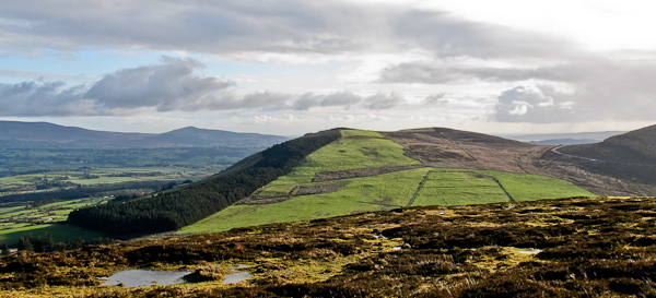
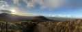
Picture: As seen from Knocksculloge
Start from the forest entrance at Knocksculloge (S13175 06653) , room for 5 cars. Walk up the track to a junction. Turn left and walk to around A (S1396 0621). Turn NE here crossing a field then ascending through rough ground over and around the scattered remains of felled trees.
Broemountain is well positioned to give interesting views due to its location and because is has recently been clear-felled. You can reach it from the forest entrance at Knocksculloge (S13175 06653) where there is a place to park a few cars.
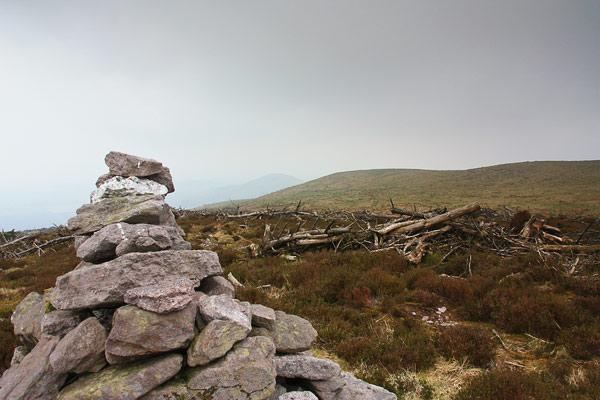
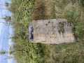
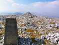
I wasn't there on a day that showed off the view however here is a picture of the fine sandstone cairn on the top - you can see the clear felling behind it. Linkback: new.mountainviews.ie/summit/696/comment/4659/
Read Less
Read More
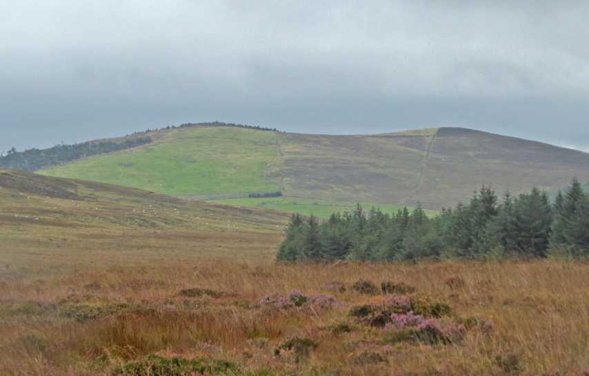
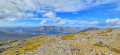
Picture: The true summit is on the left. (Taken from Knocksculloge)
Good views from so-so top
by Colin Murphy
21 Sep 2021
Followed jackal's directions and accessed the hill at A (S1396 0621), following a muddy trail up the gently rising slope. This appears to be heading to the summit, but is actually taking you to a less prominent area, visible in picture on the right. The trail appears to end around B (S142 064), but in fact branches off to the NE in a much narrower version, which leads across a grassy field to a rough, heathery area surrounded by a wall/fence. The high point is marked by a decent cairn. Linkback: new.mountainviews.ie/summit/696/comment/23282/
Use of MountainViews is governed by conditions and a privacy policy.
Read general information about the site. Opinions in material here are not necessarily endorsed by MountainViews.
Hillwalking is a risk sport. Information in comments, walks, shared GPS tracks or about starting places may
not be accurate for example as regards safety or access permission. You are responsible for your safety and your permission to walk.
See the credits and list definitions.


 (Aug 2013) by gerrym Click for player.")
 (Jul 2013) by gerrym Click for player.")
 (Jun 2013) by gerrym Click for player.")
 by miriam Click for player.")

 Add a Place Comment for Broemountain, Breo


 Our Facebook page.