Guestuser: Login or enrol?
- Home
- Main Display
- Main Display (Old)
- Find a Walk
- Display INTRODUCTION
- DONATE
- Click below for your
profile & contributions
guestuser- News
- Tracks, Walks
- Challenge
- Community
- Lists & Logs
- Popular Lists:
- County Highpoints
- Range & Area Highpoints
- Local 100
- Highest Hundred
- Vandeleur-Lynams
- Arderins
- Carns
- Best rated
- Irish 900 up
- Irish Island
- Munros
- All Lists
- Shorter Irish
- County Highpoints
- Range & Area Highpoints
- Highest Hundred
- Local 100
- Local 100 (pre2014)
- Local Historical Cultural
- Best rated
- Irish 900 up
- Larger Irish
- Arderins
- Arderin Begs
- Arderins + Arderin Begs
- Vandeleur-Lynams
- Vandeleur-Lynams + Arderins
- Carns
- Binnions
- Highest 50 per Province
- Island Features
- Irish Island
- Coastal Hills
- Irish 600 up
- Irish 500 up
- British
- Munros
- British 600 up
- British 500-600
- British Marilyns
- Comprehensive
- All Irish summits
- All Irish features
- All British summits
- All Britain+ Ireland
- Special
- Analysis List
- Simple Irish Listings
- Simple Irish & British Listings
-
- More
- Motley Views
Welcome to MountainViews
If you want to use the website often please enrol (quick and free) at top right.OverviewFor more map options click on any overview map area or any detail map feature.Detail Map FeaturesShowing 7 items:
Esknabrock 406m,Tracks:2652, 39km 4337, 17km 5360, 13km 5271, 11km 4753, 10km 2162, 4km Find Suggested Walks
Find hill, mountain, island, coastal feature.Videos


Recent Contributions
 Get Notifications
Silvermine Mountains East Top: East Top is Easy Top
Coppanagh: I'd go now if I were you.
Silvermine Mountains West Top: Fab hill
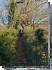
Dargle Gorge near Enniskerry, North Side.
Hell or high water
Bree Hill: Bree no longer a breeze
Rostrevor: Kilbroney Forest Park with description
Binn Chaonaigh: Havoc on the Maamturks!
Mount Kid: A small grassy hill top with amazing views towards the sea and beyond
Corraun Hill: Corraun at the double
Errisbeg Loop from Dog's Bay Beach
Knocknacloghoge: Viewed across Lough Dan
Conditions and Info
Use of MountainViews is governed by conditions and a privacy policy.
Read general information about the site.
Opinions in material here are not necessarily endorsed by MountainViews.
Hillwalking is a risk sport. Information in comments, walks, shared GPS tracks or about starting places may not be accurate for example as regards safety or access permission. You are responsible for your safety and your permission to walk.
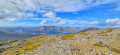
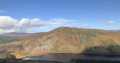
See the credits and list definitions.Video displayMangerton Area SE: Esknabrock SubareaPlace count in area: 28, OSI/LPS Maps: 78, 79, EW-KNP, EW-R
Highest place: Mangerton, 838.2m
Maximum height for area: 838.2 metres, Maximum prominence for area: 583.2 metres,
Places in area Mangerton:
Cen: Dromderlough:Dromderalough 650mDromderalough NE Top 648mDromderalough NW Top 625mKnockbrack 610mKnockrower 554mShaking Rock 402m
Cen: Inchimore:Inchimore 256m
Cen: Mangerton:Glencappul Top 700mMangerton 838.2mMangerton North Top 782mStoompa 705mStoompa East Top 608m
NE: Crohane:Bennaunmore 454mCarrigawaddra 425mCrohane 650mCrohane SW Top 477m
NW: Torc:Cromaglan Mountain 371mTorc Mountain 534.8mTorc Mountain West Top 479.4m
SE: Esknabrock:Esknabrock 406m
SW: Peakeens:Derrygarriff 492mDerrygarriff West Top 382mFoardal 409.8mKnockanaguish 509mPeakeen Mountain 554.7mPeakeen Mountain Far NW Top 525.5mPeakeen Mountain North-West Top 522.7mPeakeen Mountain West Top 538.7m
Note: this list of places includes island features such as summits, but not islands as such.
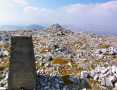
Kerry County in Munster Province, in Carn List, Pebbly sandstone & conglomerate Bedrock
Height: 406m OS 1:50k Mapsheet: 79 Grid Reference: W02688 77152
Place visited by 22 members. Recently by: compassman, DeirdreM, Colin Murphy, Grumbler, hivisibility, learykid, daitho9, chelman7, markmjcampion, Fergalh, ciarraioch, eamonoc, frankmc04, ShayGlynn, ahendroffI have visited this place: NO (You need to be a logged-in member to change this.)Longitude: -9.415685, Latitude: 51.938529 , Easting: 102688, Northing: 77152 Prominence: 251m, Isolation: 4.9km
ITM: 502660 577216 , GPS IDs, 6 char: Esknbr, 10 char: Esknabrock
Bedrock type: Pebbly sandstone & conglomerate, (Doo Lough Pebbly Sandstone Member)
Previously Cappanlivane in MV. Esknabrock is the 917th highest place in Ireland.
Linkback: https://new.mountainviews.ie/summit/799/COMMENTS for Esknabrock (Eisc na mBroc) 1 of 1
Follow this place's comments
Height layer: © MapTiler

MountainViews.ie, a Hill-walking Website for the island of Ireland. 2500 Summiteers, 1480 Contributors, maintainer of lists such as: Arderins, Vandeleur-Lynams, Highest Hundred, County Highpoints etc
 Leatra
 chelman7
 Leatra
 simon3
 Colin Murphy
 chelman7
 jackill
 Colin Murphy
 melohara
 Visit our Facebook page.