Guestuser: Login or enrol?
- Home
- Main Display
- Main Display (Old)
- Find a Walk
- Display INTRODUCTION
- DONATE
- Click below for your
profile & contributions
guestuser- News
- Tracks, Walks
- Challenge
- Community
- Lists & Logs
- Popular Lists:
- County Highpoints
- Range & Area Highpoints
- Local 100
- Highest Hundred
- Vandeleur-Lynams
- Arderins
- Carns
- Best rated
- Irish 900 up
- Irish Island
- Munros
- All Lists
- Shorter Irish
- County Highpoints
- Range & Area Highpoints
- Highest Hundred
- Local 100
- Local 100 (pre2014)
- Local Historical Cultural
- Best rated
- Irish 900 up
- Larger Irish
- Arderins
- Arderin Begs
- Arderins + Arderin Begs
- Vandeleur-Lynams
- Vandeleur-Lynams + Arderins
- Carns
- Binnions
- Highest 50 per Province
- Island Features
- Irish Island
- Coastal Hills
- Irish 600 up
- Irish 500 up
- British
- Munros
- British 600 up
- British 500-600
- British Marilyns
- Comprehensive
- All Irish summits
- All Irish features
- All British summits
- All Britain+ Ireland
- Special
- Analysis List
- Simple Irish Listings
- Simple Irish & British Listings
-
- More
- Motley Views
Welcome to MountainViews
If you want to use the website often please enrol (quick and free) at top right.OverviewFor more map options click on any overview map area or any detail map feature.Detail Map FeaturesShowing 1 items:
Gregory Hill 336m,Find Suggested Walks
Find hill, mountain, island, coastal feature.Videos
Recent Contributions
 Get Notifications
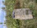
Silvermine Mountains East Top: East Top is Easy Top
Coppanagh: I'd go now if I were you.
Silvermine Mountains West Top: Fab hill
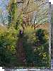
Dargle Gorge near Enniskerry, North Side.
Hell or high water
Bree Hill: Bree no longer a breeze
Rostrevor: Kilbroney Forest Park with description
Binn Chaonaigh: Havoc on the Maamturks!
Mount Kid: A small grassy hill top with amazing views towards the sea and beyond
Corraun Hill: Corraun at the double
Errisbeg Loop from Dog's Bay Beach
Knocknacloghoge: Viewed across Lough Dan
Conditions and Info
Use of MountainViews is governed by conditions and a privacy policy.
Read general information about the site.
Opinions in material here are not necessarily endorsed by MountainViews.
Hillwalking is a risk sport. Information in comments, walks, shared GPS tracks or about starting places may not be accurate for example as regards safety or access permission. You are responsible for your safety and your permission to walk.
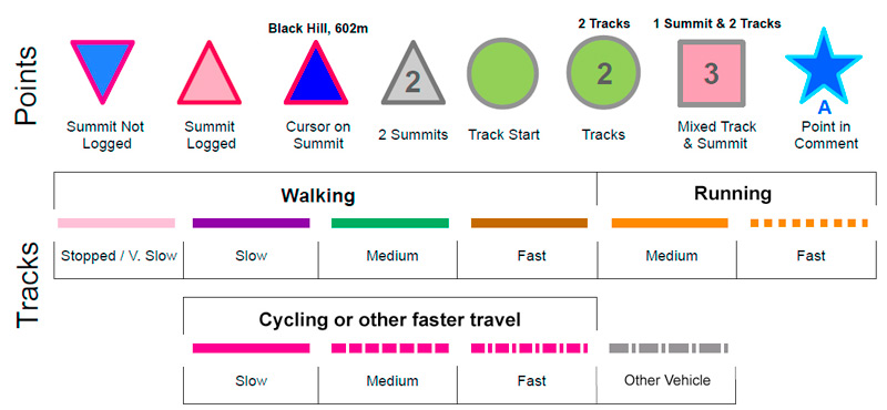
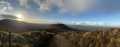
See the credits and list definitions.Video displayDonegal East Area NW: Letterkenny Hills SubareaPlace count in area: 12, OSI/LPS Maps: 11, 12, 6, 7
Highest place: Culliagh SE Top, 369m
Maximum height for area: 369 metres, Maximum prominence for area: 241 metres,
Places in area Donegal East:
N: Raphoe:Binnion Hill 190mDooish Mountain 266mHigh Bank 171mMongorry Hill 284m
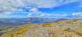
NW: Letterkenny Hills:Ballystrang 292mCark Mountain 364mCulliagh SE Top 369mGregory Hill 336mKnockbrin 259m
S: Castlefinn Hills:Croaghan Hill 217mFearns Hill 231mMeenavally 219m
Note: this list of places includes island features such as summits, but not islands as such.
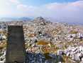
(poss. Ir. ‡Cnoc Mhic Gréagóir [PDT], 'hill of the Gregory family') Donegal County in Ulster Province, in Binnion List, Banded semi-pelitic & psammitic schist Bedrock
Height: 336m OS 1:50k Mapsheet: 6 Grid Reference: C11618 12412
Place visited by 24 members. Recently by: LorraineG60, MichaelG55, dregish, conormcbandon, Carolyn105, Wilderness, AntrimRambler, jackill, eamonoc, Fergalh, magicstep, Aidy, sandman, chalky, mark-rdcI have visited this place: NO (You need to be a logged-in member to change this.)Longitude: -7.819431, Latitude: 54.959111 , Easting: 211618, Northing: 412412 Prominence: 241m, Isolation: 5.5km, Has trig pillar
ITM: 611565 912398 , GPS IDs, 6 char: GrgrHl, 10 char: GrgryHil
Bedrock type: Banded semi-pelitic & psammitic schist, (Termon Formation)
Overlooks Letterkenny. So named from a family in whose possession it was about 60 years since. [OSNB] Gregory Hill is the third highest hill in the Donegal East area and the 1088th highest in Ireland. Gregory Hill is the second most northerly summit in the Donegal East area.
Linkback: https://new.mountainviews.ie/summit/916/COMMENTS for Gregory Hill (Cnoc Mhic Gréagóir) 1 of 1
Follow this place's comments
Height layer: © MapTiler

MountainViews.ie, a Hill-walking Website for the island of Ireland. 2500 Summiteers, 1480 Contributors, maintainer of lists such as: Arderins, Vandeleur-Lynams, Highest Hundred, County Highpoints etc
 Leatra
 chelman7
 Leatra
 simon3
 Colin Murphy
 chelman7
 jackill
 Colin Murphy
 melohara
 Visit our Facebook page.