Warning: Undefined variable $trackExportPanel in /var/www/vhosts/new.mountainviews.ie/httpdocs/mv/classes/display/RWD/trackSupportClass.php on line 1099 Walk in Ireland Knockmulanane Knockmulanane West Top, ascent 406m, length 6.8km
Cookies.
This website uses cookies, which are small text files that the website puts on your device to facilitate operation. Cookies help us provide a better service to you. They are used to track general user traffic information and to help the website function properly.
MountainViews is standardising on this new presentation style for the "Main Page". For a short while it is still possible to
Get the equivalent "old" page here. Or choose from the "Home" menu option above to change.
simon3: Track/4265 in area near Knockmulanane, Central Dingle (Ireland)
Short, steep visit to both Knockmulananes
Ascent: 406m,
Length: 6.8km,
Creator time taken: 3h49m
Descent: 560m,
Time predicted from Naismith's rule: 2h 2m + breaks
Click here to rate track
PlacesStart at Annascaul Lake (AnScaul L) Q58285 04991, Knockmulanane, Knockmulanane West Top, end at Start
Track Rating ..
[RWD version 1 ]
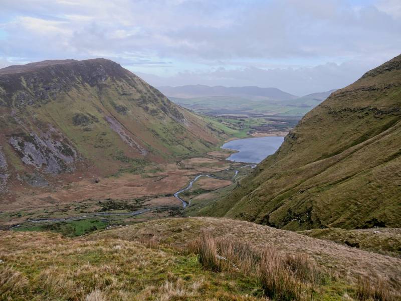
This route starts from the carpark beside Lough Annascaul.
Lough Annascaul. Knockmulanane to the left, cliff off Dromavally to centre.
It goes straight up to Knockmulanane starting from a point about 100m south of the carpark.
Steep slope up from road. Further south, beyond bottom right of picture is recommended.
Although we managed this extremely steep route on broken ground with wet grass, a better start would probably be about 200m south of the carpark where there is a more regular slope. (See track/2237, which looks better) Under no circumstances would this be a good route for beginners, either going up or down. There is a substantial cairn at the top of the slope and two more further west. The westmost is the top. There's excellent shelter from the usual SW winds near the top. The views are some of the finest Kerry has to offer including north towards Beenoskee, the magnificent Glenahoo River Valley and Brandon Bay. To the south there is Dingle Bay and beyond to the north Iveragh peninsula with Knocknadobar and many other summits visible.
Knockmulanane summit overlooking Dingle Bay
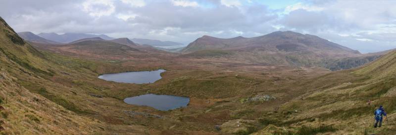
As you walk towards the minor peak of Knockmulanane West 563m savour the experience of being on a ridge overlooking so much on both sides including lakes, rivers, sea and mountains. To the north is Loch Thuairin Mhárta and a smaller lough to its SE. Also keep a look out for how you are going to get down. This is not at all a trivial choice because the land is steep and includes some substantial crags.
On the way down diagonal sloping track. Loch Thuarain Mhárta to left and upper.
You should be able to see a narrow diagonally sloping track. This is a handy if not very safe way of skirting the rock and the lakes and leads you NE towards the rough ground at around 350m north of Knockmulanane. Your next task is to get down to the valley NW of Lough Annascaul. One way to do this is to head north about 1km over the rough ground to where the old green road coming from Lough Annascaul forms zigzags. We decided to opportunise on whatever we could find dropping more directly to the valley floor. The route we took shown on the map is feasible but not easy.
We descended around here. Lough Annascaul to right.
There are serious cliffs on both sides of it and wet slippery grass on the way. Once again this is not a route for beginners however it saves time. . Overall this is a relatively short walk with great views but requiring care and preferably good visibility. The descents taken demonstrate possible ways down, but both need care.
Editing Details for track/4265
NOTE: ALL information such as Ascent, Length and Creator time taken etc should be regarded as approximate. The creator's comments are opinions and may not be accurate or still correct.
Your time to complete will depend on the speed of the slowest plus break time and your mode of transport.
NOTE: It is up to you to ensure that your route is appropriate for you and your party to follow bearing in mind all factors such as safety, weather conditions, experience and access permission.
Uploaded on: Fri, 17 Jan 2020 (10:40:54), Linkback: https://new.mountainviews.ie/track/4265/
* Note: A GPS Height in the elevation profile is sourced from the device that recorded the track. An "SRTM" height is derived from a model of elevations for parts of the earth. More detail
Use of MountainViews is governed by conditions and a privacy policy.
Read general information about the site. Opinions in material here are not necessarily endorsed by MountainViews.
Hillwalking is a risk sport. Information in comments, walks, shared GPS tracks or about starting places may
not be accurate for example as regards safety or access permission. You are responsible for your safety and your permission to walk.
See the credits and list definitions.


 by mcrtchly Click for player.")
 | Dingle | Kerry (May 2016) by gerrym Click for player.")
 Click for player.")
 by gerrym Click for player.")


 Our Facebook page.