Deprecated: Implicit conversion from float 1499265.4407662665 to int loses precision in /var/www/vhosts/new.mountainviews.ie/httpdocs/mv/classes/geo/conversions/transformsClass.php on line 976
Deprecated: Implicit conversion from float 1320230.6564556463 to int loses precision in /var/www/vhosts/new.mountainviews.ie/httpdocs/mv/classes/geo/conversions/transformsClass.php on line 977
Deprecated: Implicit conversion from float 320230.6564556463 to int loses precision in /var/www/vhosts/new.mountainviews.ie/httpdocs/mv/classes/geo/conversions/transformsClass.php on line 998
Deprecated: Implicit conversion from float 999265.4407662664 to int loses precision in /var/www/vhosts/new.mountainviews.ie/httpdocs/mv/classes/geo/conversions/transformsClass.php on line 999
Warning: Undefined variable $trackExportPanel in /var/www/vhosts/new.mountainviews.ie/httpdocs/mv/classes/display/RWD/trackSupportClass.php on line 1099 Walk in Britain, ascent 223m, length 8.9km
Cookies.
This website uses cookies, which are small text files that the website puts on your device to facilitate operation. Cookies help us provide a better service to you. They are used to track general user traffic information and to help the website function properly.
MountainViews is standardising on this new presentation style for the "Main Page". For a short while it is still possible to
Get the equivalent "old" page here. Or choose from the "Home" menu option above to change.
mcrtchly: Track/4298 in area near Orkney Islands (Britain)
I'm still standing
Ascent: 223m,
Length: 8.9km,
Creator time taken: 3h32m
Descent: 225m,
Time predicted from Naismith's rule: 2h 9m + breaks
Click here to rate track
PlacesStart at ND20230 99265, end at Start
Track Rating ..
[RWD version 1 ]
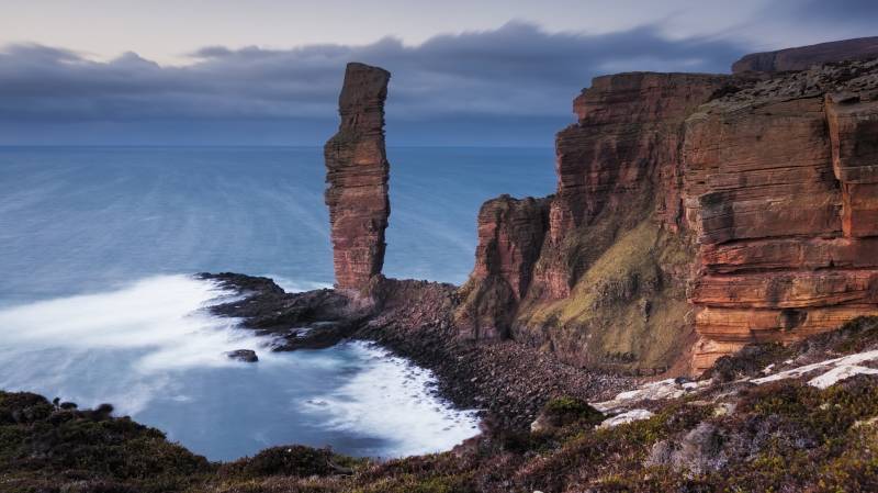
Among the must-see sites on the bucket-list of virtually every traveller to Orkney, is the Old Man of Hoy, a 137-metre sea stack on the west coast of the island of Hoy. The interest of many visitors (like us) is no doubt piqued by their first glimpse of this iconic rock formation from the deck of the MV Hamnavoe ferry that sails between Scrabster and Stromness.
Comprised of layers of soft, sandy and pebbly sandstone, and harder flagstones of Old Red Sandstone from the Devonian era (c390 ma), the Old Man rises from a plinth of basalt rock and is separated from the mainland by a 60-metre chasm strewn with debris. One of the tallest sea stacks in the United Kingdom, scurvy-grass, sea mayweed and sea campion cling to its vertical faces and nesting fulmars occupy its ledges.
The Old Man is probably less than 250 years old, and will undoubtedly collapse in future. Winds hereabouts are faster than 8 metres per second for nearly a third of the time, and gales occur on average for 29 days of a year. Combined with the depth of the sea, which quickly falls to 60 metres, high-energy waves on the western side of Hoy lead to rapid erosion of the coast.
The Old Man is not mentioned in the Orkneyinga Saga (written c.1230), and on the Blaeu map of 1600 a headland exists at the point where the Old Man is now. The McKenzie Map of Hoy, dated 1750, similarly shows a headland but no stack, but by 1819 the Old Man had been separated from the mainland. A contemporaneous sketch by William Daniell depicts the sea stack as a wider column than today, with a smaller top section and an arch at the base, giving it a human-like form, hence its name. Sometime in the early-nineteenth century, a storm washed away one of the ‘legs’ leaving it much as it is today, although erosion continues. By 1992 a 40-metre crack had appeared in the top of the south face, leaving a large overhanging section that will eventually collapse.
The Old Man is popular with climbers, and was first scaled by mountaineers Chris Bonington, Rusty Baillie and Tom Patey in 1966. From 8–9 July 1967, an ascent featured in The Great Climb, a live BBC three-night outside broadcast, which received around 15 million viewers. This featured three pairs of climbers: Bonington and Patey repeated their original route, whilst two new lines were climbed by Joe Brown and Ian McNaught-Davis, and by Pete Crew and Dougal Haston. In 1998, Catherine Destivelle was the first person to make a solo ascent of it.
To reach the stunning cliff point views of the Old Man entails a 9km-round trip from the starting point at the car park above Rackwick Bay. Allow around three hours. The route traverses very steep terrain on the west side of the bay along a road (serving a handful of cottages) via a couple of hairpin bends before it becomes a well-defined and well-maintained stony track which ascends diagonally towards the top of the cliffs across open moorland. The route passes into The Old Man of Hoy RSPB Nature Reserve which offers sweeping views over Rackwick Bay and the Pentland Firth. The route then contours around the southern base of Moor Fea (304m), and the top of the Old Man eventually looms into view. We were amazed to sight numerous mountain hares resplendent in their white winter coats as we traversed the moorland below Moor Fea, while the calls of water fowl drifted across the quiet moorland from the direction of the tiny Loch of Stourdale, a mere spoonful of gloomy water atop the cliffs.
View over Rackwick Bay from the path to the Old Man
The track leads straight to a very narrow promontory of rock which juts precariously out of the vertiginous cliff face almost opposite the Old Man at the Tuaks of the Boy. Here we carefully set up our cameras to capture some images of the Old Man as the sun sank low on the western horizon which cast an alluring golden glow over the old red sandstone. The cries of fulmars on barely visible nearby cliff ledges, was incessant. In summer, this is a great spot for puffin watching.
Warm light bathes the Old Man of Hoy at sunset
Almost as soon as we left the promontory (our anal nerves surprisingly intact!) for a photo spot further to the south, the wind picked up and began to gust violently. It would have been next to impossible to stand on the promontory in such conditions. Hunkered down on the heathery moorland atop the cliffs, we managed to keep our tripods steady enough to capture some images of the Old Man from the south during the blue hour.
The Old Man in the blue hour
data:image/gif;base64,R0lGODlhAQABAPABAP///wAAACH5BAEKAAAALAAAAAABAAEAAAICRAEAOw== We strode out across the boot-sucking boggy moorland to the north of the Loch of Stourdale which was interspersed with dwarf willow (umm, memories of wilderness trekking in Greenland and northern Sweden!!!!) to re-join the track back to the car park at Rackwick Bay, all the while keeping a keen eye on the battleship grey clouds looming on the northern horizon. We were still a few kilometres from the car park when we were predictably pelted with buckshot hail and rain!
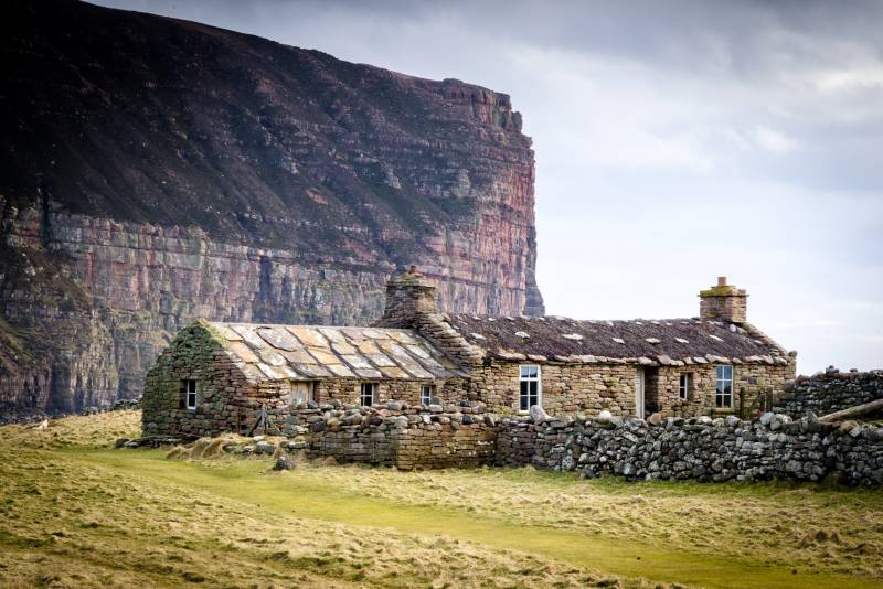
Overnight camping is permitted in the car park, but there is another option for those without a camper van: the Burnmouth Bothy at nearby Rackwick Bay. Rackwick means ‘wreckage bay’, in the Old Norse language of early Viking settlers, the name reflecting the terrible fate suffered by many ships as they attempted to cross the Pentland Firth, even in more recent times. The Orcadian poet George Mackay Brown called Rackwick ‘Orkney’s last enchantment’ and ‘the hidden valley of light’. The Burnmouth Bothy is an early-nineteenth century, single-storey, roughly rectangular-plan former crofthouse with a heather thatched roof; adjoining the northeast gable is a lower three-bay former byre with a flagstone roof. Burnmouth was used by the BBC in 1970 for an adaptation one of McKay Brown’s stories, and was later renovated by the Hoy Trust to provide shelter and accommodation for campers and hill walkers.
Burnmouth Bothy
The bothy is sited right above the cobble-strewn beach and you can lie awake at night listening to the unforgettable sound of the North Atlantic rollers pounding the shore. Facilities include sleeping platforms, table and chairs, a flush toilet, a hand basin with (non-potable) tap water, and a (rather dilapidated) wood burning stove. Although some cooking pots are provided, these didn’t look very salubrious, so bring your own, along with camping gas.
Editing Details for track/4298
NOTE: ALL information such as Ascent, Length and Creator time taken etc should be regarded as approximate. The creator's comments are opinions and may not be accurate or still correct.
Your time to complete will depend on the speed of the slowest plus break time and your mode of transport.
NOTE: It is up to you to ensure that your route is appropriate for you and your party to follow bearing in mind all factors such as safety, weather conditions, experience and access permission.
Uploaded on: Thu, 23 Apr 2020 (19:17:54), Linkback: https://new.mountainviews.ie/track/4298/
* Note: A GPS Height in the elevation profile is sourced from the device that recorded the track. An "SRTM" height is derived from a model of elevations for parts of the earth. More detail
Use of MountainViews is governed by conditions and a privacy policy.
Read general information about the site. Opinions in material here are not necessarily endorsed by MountainViews.
Hillwalking is a risk sport. Information in comments, walks, shared GPS tracks or about starting places may
not be accurate for example as regards safety or access permission. You are responsible for your safety and your permission to walk.
See the credits and list definitions.


 Our Facebook page.