- Home
- Main Display
- Main Display (Old)
- Find a Walk
- Display INTRODUCTION
- DONATE
- Click below for your
profile & contributions
guestuser- News
- Tracks, Walks
- Challenge
- Community
- Lists & Logs
- Popular Lists:
- County Highpoints
- Range & Area Highpoints
- Local 100
- Highest Hundred
- Vandeleur-Lynams
- Arderins
- Carns
- Best rated
- Irish 900 up
- Irish Island
- Munros
- All Lists
- Shorter Irish
- County Highpoints
- Range & Area Highpoints
- Highest Hundred
- Local 100
- Local 100 (pre2014)
- Local Historical Cultural
- Best rated
- Irish 900 up
- Larger Irish
- Arderins
- Arderin Begs
- Arderins + Arderin Begs
- Vandeleur-Lynams
- Vandeleur-Lynams + Arderins
- Carns
- Binnions
- Highest 50 per Province
- Island Features
- Irish Island
- Coastal Hills
- Irish 600 up
- Irish 500 up
- British
- Munros
- British 600 up
- British 500-600
- British Marilyns
- Comprehensive
- All Irish summits
- All Irish features
- All British summits
- All Britain+ Ireland
- Special
- Analysis List
- Simple Irish Listings
- Simple Irish & British Listings
-
- More
- Motley Views
Welcome to MountainViews
If you want to use the website often please enrol (quick and free) at top right.OverviewFor more map options click on any overview map area or any detail map feature.Detail Map FeaturesShowing 19 of a total of 43 items:
Letterbreckaun 667m, Letterbreckaun NE Top 603m, Meall Cheo 578m, Leacan 556.8m, Búcán 550m, Maumturkmore 488m, Knockpasheemore 412m, Letterettrin 333m, Lettershanbally 323m,Tracks:3640, 23km 4045, 20km 1332, 19km 4542, 17km 3241, 16km 928, 16km 1454, 15km 5198, 13km 1405, 12km 2486, 12km Find Suggested Walks
Find hill, mountain, island, coastal feature.Videos


Recent Contributions
 Get Notifications
Silvermine Mountains East Top: East Top is Easy Top
Coppanagh: I'd go now if I were you.
Silvermine Mountains West Top: Fab hill
Dargle Gorge near Enniskerry, North Side.
Hell or high water
Bree Hill: Bree no longer a breeze
Rostrevor: Kilbroney Forest Park with description
Binn Chaonaigh: Havoc on the Maamturks!
Mount Kid: A small grassy hill top with amazing views towards the sea and beyond
Corraun Hill: Corraun at the double
Errisbeg Loop from Dog's Bay Beach
Knocknacloghoge: Viewed across Lough Dan
Conditions and Info
Use of MountainViews is governed by conditions and a privacy policy.
Read general information about the site.
Opinions in material here are not necessarily endorsed by MountainViews.
Hillwalking is a risk sport. Information in comments, walks, shared GPS tracks or about starting places may not be accurate for example as regards safety or access permission. You are responsible for your safety and your permission to walk.
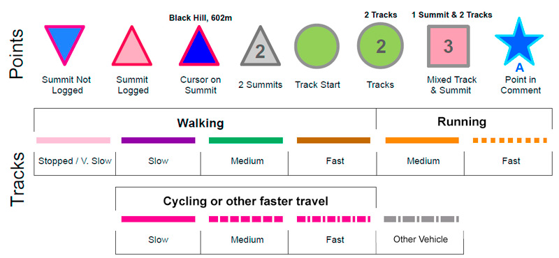
See the credits and list definitions.Video displaymarkwallace: Track 4432 in area near Twelve Bens (Ireland)Lettershanbally Loop to Lettershanbally Hill Length: 11.2km, Creator time taken: 2h28m, Ascent: 349m,
Descent: 370m
Places: Start at L8088158382, Leitir Seanbhaile, end at L7995458061 980m W from Start
Logged as completed by 1

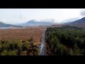
I parked at the trailhead for the newish Lettershanbally Loop and followed that loop for the first 3.5 km. Mostly standard forest track walking but the last 1 km is a nice boardwalk through flat bog, surrounded by the Maamturks and Twelve Bens. At the end of the boardwalk, the Loop meets the Western Way. Instead of following the Loop south along the Way, I headed north on the Way for 500m then crossed the fence onto the hillside at a suitable point heading for some stone ruins under some bare (at least in early March) trees. Lazy beds were also visible on the hillside above the ruins. A fresh vehicle track was visible among the ruins, so out of curiosity I followed it down to a gate, which I would pass through on the descent. Then I returned to the seanbhaile, took a few photos and headed directly up the steep, mostly grassy hilside. It was a short climb to pt. 324. The grassy hilltop has no cairn or other marker but has great views in all directions.


I headed down, taking a more northerly line as the descent was gentler in that direction. I passed close to the remains of a prehistoric fort on the lower slopes, but I didn´t cross the fence to visit it. I descended to the gate I had seen earlier. There was a lock on the gate but it was open. I followed the Western Way back to the intersection with the Lettershanbally Loop and headed back over the boardwalk. I reversed my steps rather than completing the Loop because the rest of the Loop after the boardwalk is on forestry tracks with trees blocking the view of the surroundings so it is not particularly rewarding.

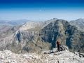
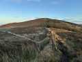
I don´t know the name of this hill. I´m guessing Lettershanbally Hill. It doesn´t fit the height/prominence criteria to go in any MV list but both from the ground and from the top it feels and looks like a fairly independent summit. It has a prominence of 90m and height 324m. The slopes drop steeply away to north, west and east, and even to the southeast where the ridge leads to its parent peak, Maamturkmore/Binn Bhán, the ground drops away for over a kilometre before beginning to rise. Maamturkmore is almost 3 km away as the crow flies, so it doesn´t feel like it dominates this hill at all. The views from the summit are very good on a day as fine as the one I was up there. Views include the grassy bulk of Leenane Hill to the North, Twelve Bens, Lough Inagh, Kylemore Lough, the Benchoonas, Killary Harbour, Mweelrea, the Sheeffreys, Ben Gorm and the Atlantic Oceanin the distance. It is also accessible from Glencraff to the north, where there is parking for the Tullyconor Loop, a loop which is very short but provides an entry point for taking on this hill, or even a full Glencraff horseshoe encompassing Leenane Hill on the other side of the valley.
I didn't start recording the track until about 800m in. So actual walk length would be about 12km rather than 11.2km as recorded. COMMENTSNo comments uploaded yet.
NOTE: ALL information such as Ascent, Length and Creator time taken etc should be regarded as approximate. The creator's comments are opinions and may not be accurate or still correct.
Your time to complete will depend on your speed plus break time and your mode of transport. For walkers: Naismith's rule, an approximate though often inaccurate estimate, suggests a time of 2h 50m + time stopped for breaks
NOTE: It is up to you to ensure that your route is appropriate for you and your party to follow bearing in mind all factors such as safety, weather conditions, experience and access permission.
* Note: A GPS Height in the elevation profile is sourced from the device that recorded the track. An "SRTM" height is derived from a model of elevations for parts of the earth. More detail Height layer: © MapTiler

MountainViews.ie, a Hill-walking Website for the island of Ireland. 2500 Summiteers, 1480 Contributors, maintainer of lists such as: Arderins, Vandeleur-Lynams, Highest Hundred, County Highpoints etc
 Leatra
 chelman7
 Leatra
 simon3
 Colin Murphy
 chelman7
 jackill
 Colin Murphy
 melohara
 Visit our Facebook page.