Warning: Undefined variable $trackExportPanel in /var/www/vhosts/new.mountainviews.ie/httpdocs/mv/classes/display/RWD/trackSupportClass.php on line 1099 Walk in Ireland Killerry Mountain, ascent 283m, length 6.6km
Cookies.
This website uses cookies, which are small text files that the website puts on your device to facilitate operation. Cookies help us provide a better service to you. They are used to track general user traffic information and to help the website function properly.
MountainViews is standardising on this new presentation style for the "Main Page". For a short while it is still possible to
Get the equivalent "old" page here. Or choose from the "Home" menu option above to change.
simon3: Track/5181 in area near Killerry Mountain, Ox Mountains (Ireland)
Killerry Mountain
Ascent: 283m,
Length: 6.6km,
Creator time taken: 3h11m
Descent: 315m,
Time predicted from Naismith's rule: 1h 47m + breaks
Click here to rate track
PlacesStart at Slishwood CP (Slish Wd) G73885 31428, Killerry Mountain, end at Start
Track Rating ..
[RWD version 1 ]
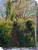
This is a route up Killerry Mountain from the northside, starting from the Slish Wood car park just south of Lough Gill. Although the Open Street Map shows a path starting south through trees and heading for the summit, NO such path exists. The route is extremely rough both through the forest and for the first 100m or so of ascent. Much of the open terrain in this stretch is a jumble of deep grass, some ferns, some boggy bits with bog myrtle and hidden ruts. On the steeper ground above 200m the walking becomes easier with deer grass, dwarf furze and bell heather. There is the occasional animal track. Subsequently we learnt that there are easier approaches from the east of Killerry or the NW of the Slish Wood carpark.
Editing Details for track/5181
NOTE: ALL information such as Ascent, Length and Creator time taken etc should be regarded as approximate. The creator's comments are opinions and may not be accurate or still correct.
Your time to complete will depend on the speed of the slowest plus break time and your mode of transport.
NOTE: It is up to you to ensure that your route is appropriate for you and your party to follow bearing in mind all factors such as safety, weather conditions, experience and access permission.
Uploaded on: Sun, 13 Oct 2024 (06:32:25), Linkback: https://new.mountainviews.ie/track/5181/
* Note: A GPS Height in the elevation profile is sourced from the device that recorded the track. An "SRTM" height is derived from a model of elevations for parts of the earth. More detail
Use of MountainViews is governed by conditions and a privacy policy.
Read general information about the site. Opinions in material here are not necessarily endorsed by MountainViews.
Hillwalking is a risk sport. Information in comments, walks, shared GPS tracks or about starting places may
not be accurate for example as regards safety or access permission. You are responsible for your safety and your permission to walk.
See the credits and list definitions.


 by gerrym Click for player.")
 by patrickzerkowski Click for player.")
 Click for player.")


 Our Facebook page.