This website uses cookies, which are small text files that the website puts on your device to facilitate operation. Cookies help us provide a better service to you. They are used to track general user traffic information and to help the website function properly.
MountainViews is standardising on this new presentation style for the "Main Page". For a short while it is still possible to
Get the equivalent "old" page here. Or choose from the "Home" menu option above to change.
Summits & other features in area North East Midlands: Boyne Valley: Hill of Ward 111m Cen: Ballyjamesduff: Aghalion Hill 249m Cen: Oldcastle: Mullaghmeen 258m, Slieve Na Calliagh 276m, Spire of Lloyd 131m, The Hill of Mael 241m E: Kingscourt: Carrickleck Hill 173m N Cen: Cavan Town: Shantemon 218m, Slieve Glah 320m, Tievenanass 261m NE: Ballybay: Bunnanimma 268m NE: Carrickmacross: Corduff 243m NE: Castleblaney: Mullyash Mountain 317m NE: Cen Bailieborough: Cornasaus 339m, Taghart South 290m NW Cen: Arva: Bruse Hill 260m NW: Aughavas: Lugganammer 190m S Cen: Crookedwood: Cruckboeltane 199m, Knockeyon 214m S: Westmeath South West: Knockastia 200m SE: Boyne Valley: Hill of Slane 160.4m, Mount Oriel 251m, Tara 155m W: Ardagh: Bawn Mountain 200m W: Drumlish: Corn Hill 278m
Note: this list of places may include island features such as summits, but not
islands as such.
Hill of Ward, 111mHill Tlachta A name in Irish,
Place Rating ..
From Tlachtaga daughter of a druid. Tlachtaga was reputedly buried on the hill., Meath County in Leinster province, in Local/Historical/Cultural Lists, Hill of Ward is the 1509th highest place in Ireland.
Grid Reference N73583 64538,
Mapsheet(s): 42 Place visited by: 8members, recently by: sandman, mehiking, abcd, Dessie1, Pepe, MickM45, tanseyman, Fergalh
I visited this place: NO (You need to be a logged-in member for this.)
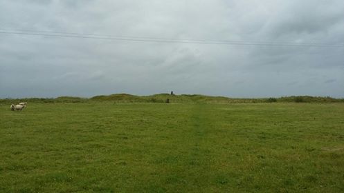
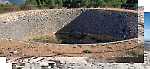
Tlachtga is the prehistoric name for this hill the name changed to Hill of Ward in honour of a local landlord evicted during the Cromwellian conquest of Ireland.
The Hill is considered the birth place of Halloween where the Ancient Gaelic festival of Samhain was celebrated and in modern times the Puca Festival in Athboy celebrates the original origins and have historical tours to the hill.
Site access is normally restricted due to the fact that sheep are grazed on the hill. Plans are afoot in the future to have guided tours of the site according to the lovely couple who own the site and were so kind to allow me access. Linkback: new.mountainviews.ie/summit/1526/comment/24564/
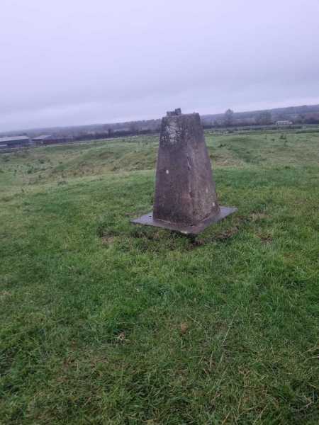
Parking for one car at gate to the south west a short drive from Athboy at a crossroads A (N735 644). Short walk to summit from stile through a field. Aerial photographs show the ring fort better than can be seen on ground although the rings are noticeable. The Spire of Lloyd and Tara Hill can be seen from the summit which has good views despite the small height Linkback: new.mountainviews.ie/summit/1526/comment/24331/
Read Less
Read More
There must be a key somewhere hereabouts...
by Pepe
15 Feb 2025
Mounted the style only to find a large shiny padlock on the gate and it was locked against me - maybe the key is held somewhere locally, as is the practice in nearby Lough Crew (is this a Meath thing?)
Walked two-three hundred metres east from the crossroads and entered a driveway from where the trig is visible to your right. Accessed the site from here though it involved some fence hopping. Linkback: new.mountainviews.ie/summit/1526/comment/24382/
Use of MountainViews is governed by conditions and a privacy policy.
Read general information about the site. Opinions in material here are not necessarily endorsed by MountainViews.
Hillwalking is a risk sport. Information in comments, walks, shared GPS tracks or about starting places may
not be accurate for example as regards safety or access permission. You are responsible for your safety and your permission to walk.
See the credits and list definitions.


 Add a Place Comment for Hill of Ward, Tlachta


 Our Facebook page.