This website uses cookies, which are small text files that the website puts on your device to facilitate operation. Cookies help us provide a better service to you. They are used to track general user traffic information and to help the website function properly.
MountainViews is standardising on this new presentation style for the "Main Page". For a short while it is still possible to
Get the equivalent "old" page here. Or choose from the "Home" menu option above to change.
Feature count in area: 24, all in Donegal,
OSI/LPS Maps: 1, 10, 11, 17, EW-BS, EW-DV
Highest Place: Carn More Hill 116m
Starting Places (3) in area Donegal Coastal Hill: Ardmore Road, Bluestack Centre, Mín Uí Bhaoil
Summits & other features in area Donegal Coastal Hill: Ardeelan Hill 62m, Ardeskin 64m, Ball Hill 62m, Carn More Hill 116m, Carntullagh 52m, Carrick 88m, Annagry Hill 106m, Coolmore 61m, Dromore Upper 79m, Drumchory 53m, Drumcliff Hill 58m, Drumgowan 76m, Drumgun 67m, Drumlongfield 62m, Drummanus 55m, Mullanasole 51m, Raforker 58m, Rarooey Hill 85m, Rathinny 53m, Rossyvolan 60m, Roughan 59m, Sentry Hill 62m, Tullyearl 50m, Tullywee 66m
Note: this list of places may include island features such as summits, but not
islands as such.
Drumcliff Hill, 58mCoastal Hill
Place Rating ..
, Donegal County in Ulster province, in Coastal Hill Lists Grid Reference G92400 78300,
Mapsheet(s): 11 Place visited by: 2members, recently by: Fergalh, Pepe
I visited this place: NO (You need to be a logged-in member for this.)
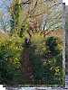
Take the western exit from the Diamond (town centre). It's only a hundred metres or so to the River Eske roadbridge. Do not venture from the bridge up the hill to Drumcliff terrace. Instead, take the bank walk down along the western side of the river toward the bay. The Bank Walk is well signed (and mapped) as you enter it. Keep an eye on that row of houses on your RHS side as you stroll along - the houses are visible through gaps in the trees and hedges above your right shoulder.
When you have passed the furthest house at the far end of the terrace, turn sharply right and climb the bank for a few metres to a fence. Hop the fence into a field. Go up past a gate to a second field. The approximate position of the high point is up at the northernmost corner of this second field. Linkback: new.mountainviews.ie/summit/1547/comment/24537/
Read Less
Read More
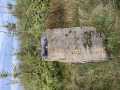
Picture: View from the summit
Short trek to summit
by Fergalh
28 Sep 2025
Parked at A (G927 787) and followed Pepe's excellent instructions crossed first fence a little further west and at second field there was a gap in the trees . Headed to north east corner of this field for high point Linkback: new.mountainviews.ie/summit/1547/comment/24553/
Use of MountainViews is governed by conditions and a privacy policy.
Read general information about the site. Opinions in material here are not necessarily endorsed by MountainViews.
Hillwalking is a risk sport. Information in comments, walks, shared GPS tracks or about starting places may
not be accurate for example as regards safety or access permission. You are responsible for your safety and your permission to walk.
See the credits and list definitions.


 by patrickzerkowski Click for player.")
 and Sturrall Head (Dec 2015) by patrickzerkowski Click for player.")
 by mcrtchly Click for player.")
 by gerrym Click for player.")

 Add a Place Comment for Drumcliff Hill


 Our Facebook page.