Warning: Undefined variable $trackExportPanel in /var/www/vhosts/new.mountainviews.ie/httpdocs/mv/classes/display/RWD/trackSupportClass.php on line 1099 Walk in Ireland Mullaghaneany Meenard Mountain Oughtmore Spelhoagh Craigagh Hill, ascent 611m, length 13.4km
Cookies.
This website uses cookies, which are small text files that the website puts on your device to facilitate operation. Cookies help us provide a better service to you. They are used to track general user traffic information and to help the website function properly.
MountainViews is standardising on this new presentation style for the "Main Page". For a short while it is still possible to
Get the equivalent "old" page here. Or choose from the "Home" menu option above to change.
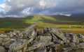
simon3: Track/2143 in area near Mullaghaneany, Sperrin Mountains (Ireland)
Crooked Burn Circuit, Banagher Forest, Sperrins.
Ascent: 611m,
Length: 13.4km,
Creator time taken: 4h28m
Descent: 652m,
Time predicted from Naismith's rule: 3h 42m + breaks
Click here to rate track
PlacesStart at Glenedra Bridge C70684 00281, Mullaghaneany, Meenard Mountain, Oughtmore, Spelhoagh, Craigagh Hill, end at Start
Track Rating ..
[RWD version 1 ]
This route starts from the B40 north of Cookstown and takes in two VLs and two other summits on the way back. The initial climb is along a forest track which gains height quickly. Leaving this is harder work over somewhat rougher ground to Mullaghaneany.
Editing Details for track/2143
NOTE: ALL information such as Ascent, Length and Creator time taken etc should be regarded as approximate. The creator's comments are opinions and may not be accurate or still correct.
Your time to complete will depend on the speed of the slowest plus break time and your mode of transport.
NOTE: It is up to you to ensure that your route is appropriate for you and your party to follow bearing in mind all factors such as safety, weather conditions, experience and access permission.
Uploaded on: Sun, 30 Sep 2012 (20:50:55), Linkback: https://new.mountainviews.ie/track/2143/
* Note: A GPS Height in the elevation profile is sourced from the device that recorded the track. An "SRTM" height is derived from a model of elevations for parts of the earth. More detail
Use of MountainViews is governed by conditions and a privacy policy.
Read general information about the site. Opinions in material here are not necessarily endorsed by MountainViews.
Hillwalking is a risk sport. Information in comments, walks, shared GPS tracks or about starting places may
not be accurate for example as regards safety or access permission. You are responsible for your safety and your permission to walk.
See the credits and list definitions.


 by gerrym Click for player.")
 by gerrym Click for player.")
 (Feb 2013) by gerrym Click for player.")
 by gerrym Click for player.")


 Our Facebook page.