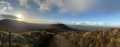
Warning: Undefined variable $trackExportPanel in /var/www/vhosts/new.mountainviews.ie/httpdocs/mv/classes/display/RWD/trackSupportClass.php on line 1099 Walk in Ireland Esknabrock, ascent 263m, length 3.7km
Cookies.
This website uses cookies, which are small text files that the website puts on your device to facilitate operation. Cookies help us provide a better service to you. They are used to track general user traffic information and to help the website function properly.
MountainViews is standardising on this new presentation style for the "Main Page". For a short while it is still possible to
Get the equivalent "old" page here. Or choose from the "Home" menu option above to change.
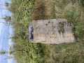
thomas_g: Track/2162 in area near Esknabrock, Mangerton (Ireland)
A quickie that's firm underfoot
Ascent: 263m,
Length: 3.7km,
Creator time taken: 58m43s
Descent: 253m,
Time predicted from Naismith's rule: 1h 10m + breaks
Click here to rate track
PlacesStart at Hidden Valley Pet Farm (HidVal PetFm) W01491 77286, Esknabrock, end at Start
Track Rating ..
[RWD version 1 ]
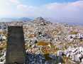
Parking at W01494 77290 is just enough for one car, go through gate and follow track to its end, over the gate and then head for the peak, crossing one fence on the way.
Editing Details for track/2162
NOTE: ALL information such as Ascent, Length and Creator time taken etc should be regarded as approximate. The creator's comments are opinions and may not be accurate or still correct.
Your time to complete will depend on the speed of the slowest plus break time and your mode of transport.
NOTE: It is up to you to ensure that your route is appropriate for you and your party to follow bearing in mind all factors such as safety, weather conditions, experience and access permission.
Uploaded on: Fri, 3 May 2013 (17:51:31), Linkback: https://new.mountainviews.ie/track/2162/
* Note: A GPS Height in the elevation profile is sourced from the device that recorded the track. An "SRTM" height is derived from a model of elevations for parts of the earth. More detail
Use of MountainViews is governed by conditions and a privacy policy.
Read general information about the site. Opinions in material here are not necessarily endorsed by MountainViews.
Hillwalking is a risk sport. Information in comments, walks, shared GPS tracks or about starting places may
not be accurate for example as regards safety or access permission. You are responsible for your safety and your permission to walk.
See the credits and list definitions.


 by mcrtchly Click for player.")
 Click for player.")

 Click for player.")


 Our Facebook page.