Warning: Undefined variable $trackExportPanel in /var/www/vhosts/new.mountainviews.ie/httpdocs/mv/classes/display/RWD/trackSupportClass.php on line 1099 Walk in Ireland Doughruagh South Top Doughruagh Garraun South Top Altnagaighera Garraun Benchoona East Top Benchoona, ascent 987m, length 14.7km
Cookies.
This website uses cookies, which are small text files that the website puts on your device to facilitate operation. Cookies help us provide a better service to you. They are used to track general user traffic information and to help the website function properly.
MountainViews is standardising on this new presentation style for the "Main Page". For a short while it is still possible to
Get the equivalent "old" page here. Or choose from the "Home" menu option above to change.
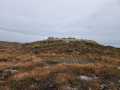
David-Guenot: Track/3074 in area near Doughruagh South Top, Twelve Bens (Ireland)
DOUGHRUAGH/GARRAUN/BENCHOONA
Ascent: 987m,
Length: 14.7km,
Creator time taken: 6h 8m
Descent: 983m,
Time predicted from Naismith's rule: 4h 35m + breaks
Click here to rate track
PlacesStart at Kylemore Abbey Exit (KylMor) L74866 58148, Doughruagh South Top, Doughruagh, Garraun South Top, Altnagaighera, Garraun, Benchoona East Top, Benchoona, end at Owengar Bridge (OwGar Br) L77988 62053, 5km NE from Start
Track Rating ..
[RWD version 1 ]
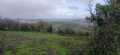
We parked in Kylemore Abbey, which did not serve us as we were told we were not allowed to climb from this side, so we walked about two miles along the busy N59 before we could find a convenient place to start our ascent. We found out later that there is room for at least two cars further on (E) along the road. Doughruagh is a beautiful mountain despite its rather modest height, steep from all sides and the summit area is really worth exploring to enjoy all the different viewpoints. Most of the climbing is done once you have reached Garraun S Top, but then it is definitely worth continuing to Garraun SW Top (Altnagaighera). The rest of the walk is a stroll with great views, particularly if you are lucky enough as we were to be able to see Mighty Mweelrea totally uncovered to the N !! Please note that the beginning of the descent is VERY steep on that side of Benchoona and I would definitely not recommend this route down under wet conditions or poor visibility. Two cars needed.
Editing Details for track/3074
NOTE: ALL information such as Ascent, Length and Creator time taken etc should be regarded as approximate. The creator's comments are opinions and may not be accurate or still correct.
Your time to complete will depend on the speed of the slowest plus break time and your mode of transport.
NOTE: It is up to you to ensure that your route is appropriate for you and your party to follow bearing in mind all factors such as safety, weather conditions, experience and access permission.
Uploaded on: Sat, 1 Aug 2015 (22:32:24), Linkback: https://new.mountainviews.ie/track/3074/
* Note: A GPS Height in the elevation profile is sourced from the device that recorded the track. An "SRTM" height is derived from a model of elevations for parts of the earth. More detail
Use of MountainViews is governed by conditions and a privacy policy.
Read general information about the site. Opinions in material here are not necessarily endorsed by MountainViews.
Hillwalking is a risk sport. Information in comments, walks, shared GPS tracks or about starting places may
not be accurate for example as regards safety or access permission. You are responsible for your safety and your permission to walk.
See the credits and list definitions.


 Click for player.")
 by mcrtchly Click for player.")
 Click for player.")
 by gerrym Click for player.")


 Our Facebook page.