Warning: Undefined variable $trackExportPanel in /var/www/vhosts/new.mountainviews.ie/httpdocs/mv/classes/display/RWD/trackSupportClass.php on line 1099 Walk in Ireland Mount Alto, ascent 397m, length 15.5km
Cookies.
This website uses cookies, which are small text files that the website puts on your device to facilitate operation. Cookies help us provide a better service to you. They are used to track general user traffic information and to help the website function properly.
MountainViews is standardising on this new presentation style for the "Main Page". For a short while it is still possible to
Get the equivalent "old" page here. Or choose from the "Home" menu option above to change.
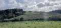
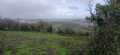
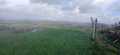
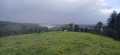
conormcbandon: Track/3135 in area near Mount Alto, South Midlands (Ireland)
A riverside walk combined followed by a summit
Ascent: 397m,
Length: 15.5km,
Creator time taken: 3h54m
Descent: 388m,
Time predicted from Naismith's rule: 3h 46m + breaks
Click here to rate track
PlacesStart at Inistioge (InsTiog) S63526 37772, Mount Alto, end at Start
Track Rating ..
[RWD version 1 ]
I parked in the village of Inistioge and followed the Leinster way along the River Nore. It was quite nice and also passed an Ice House belonging to the big house. Closer to the summit I missed the right hand turn off for Mount Alto as it's quite subtle so watch for this. There is a digger at the clearing so maybe they will be clearing that turn off soon? My approach from the south was not easy as there was wind fallen trees and rhododendrens. T
Editing Details for track/3135
NOTE: ALL information such as Ascent, Length and Creator time taken etc should be regarded as approximate. The creator's comments are opinions and may not be accurate or still correct.
Your time to complete will depend on the speed of the slowest plus break time and your mode of transport.
NOTE: It is up to you to ensure that your route is appropriate for you and your party to follow bearing in mind all factors such as safety, weather conditions, experience and access permission.
Uploaded on: Sun, 4 Oct 2015 (17:13:43), Linkback: https://new.mountainviews.ie/track/3135/
* Note: A GPS Height in the elevation profile is sourced from the device that recorded the track. An "SRTM" height is derived from a model of elevations for parts of the earth. More detail
Use of MountainViews is governed by conditions and a privacy policy.
Read general information about the site. Opinions in material here are not necessarily endorsed by MountainViews.
Hillwalking is a risk sport. Information in comments, walks, shared GPS tracks or about starting places may
not be accurate for example as regards safety or access permission. You are responsible for your safety and your permission to walk.
See the credits and list definitions.


 by Alyn Click for player.")


 Our Facebook page.