Warning: Undefined variable $trackExportPanel in /var/www/vhosts/new.mountainviews.ie/httpdocs/mv/classes/display/RWD/trackSupportClass.php on line 1099 Walk in , ascent 1049m, length 22.7km
Cookies.
This website uses cookies, which are small text files that the website puts on your device to facilitate operation. Cookies help us provide a better service to you. They are used to track general user traffic information and to help the website function properly.
MountainViews is standardising on this new presentation style for the "Main Page". For a short while it is still possible to
Get the equivalent "old" page here. Or choose from the "Home" menu option above to change.
Ascent: 1049m,
Length: 22.7km,
Creator time taken: 6h19m
Descent: 2279m,
Time predicted from Naismith's rule: 6h 17m + breaks
Click here to rate track
PlacesStart at Lon -3.48686, Lat 37.0104, end at Lon -3.54155, Lat 36.9758, 6.2km SW from Start
Track Rating ..
[RWD version 1 ]
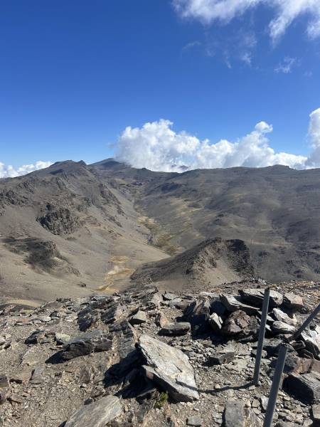
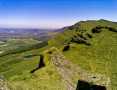
Cerro De Caballo is the lowest of the 3,000m mountains of Sierra Nevada, at between 3,005 and 3,011m depending on the map. Awkward to get at, the route involves a 4x4 taxi from Niguelas to the Mirador de la Rinconada de Niguelas at over 2,000m, after which it is straightforward - roughly 3:15 got me to the peak and back to the Mirador. There remained the issue of getting back to Niguelas. Although there is a rough road, I didn't fancy a 14k road descent, so I plotted a more interesting way down making use of a number of waymarked trails.
Cerro de Caballo from the route out
Editing Details for track/5359
NOTE: ALL information such as Ascent, Length and Creator time taken etc should be regarded as approximate. The creator's comments are opinions and may not be accurate or still correct.
Your time to complete will depend on the speed of the slowest plus break time and your mode of transport.
NOTE: It is up to you to ensure that your route is appropriate for you and your party to follow bearing in mind all factors such as safety, weather conditions, experience and access permission.
Uploaded on: Wed, 1 Oct 2025 (17:06:24), Linkback: https://new.mountainviews.ie/track/5359/
* Note: A GPS Height in the elevation profile is sourced from the device that recorded the track. An "SRTM" height is derived from a model of elevations for parts of the earth. More detail
Use of MountainViews is governed by conditions and a privacy policy.
Read general information about the site. Opinions in material here are not necessarily endorsed by MountainViews.
Hillwalking is a risk sport. Information in comments, walks, shared GPS tracks or about starting places may
not be accurate for example as regards safety or access permission. You are responsible for your safety and your permission to walk.
See the credits and list definitions.


 Our Facebook page.